New Flood Maps for Hilton Head Island
Posted by The Cobb Group on
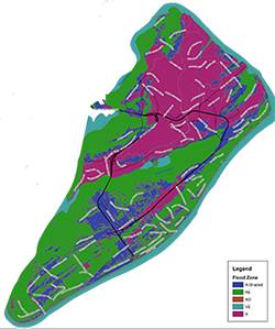
The Town of Hilton Head Island sent out a News Release this week with FEMA's new flood maps. You can search your address and see to what extent your property is at risk for flooding.
The flood zone terminology has changed too. 
Zone X (formerly Zone C) – low-risk zone
Zone Shaded X (formerly Zone B) – moderate-risk zone (0.2% annual chance flood) Zone AO – areas of shallow flooding
Zone AE – high-risk zone (1% annual chance Flood)
Zone VE – coastal high-hazard zone
Click here to check your address!
1508 Views, 0 Comments


 Heroes on Horseback is a foundation that is near and dear to our hearts here at The Cobb Group. We are so excited for this upcoming event, so we wanted to share it with you all.
 We've all heard it before, growing your mind will grow your business and personal life. So why don't we do it then? We have so many excuses. I'll do it when I have time, next week, tonight...later. The truth is, we need to be doing it now. Can you put a practice in place of reading something, journaling, or listening to a podcast just 15 min a day? One thing that all successful people have in common is that they focus on growing. What's the old saying? If you're not growing, you're dying. Well we certainly don't want that.

 Oktoberfest at Hewitt Oaks!

