The Town of Hilton Head Island sent out a News Release this week with FEMA's new flood maps. You can search your address and see to what extent your property is at risk for flooding.
The flood zone terminology has changed too. 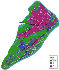
Zone X (formerly Zone C) – low-risk zone
Zone Shaded X (formerly Zone B) – moderate-risk zone (0.2% annual chance flood) Zone AO – areas of shallow flooding
Zone AE – high-risk zone (1% annual chance Flood)
Zone VE – coastal high-hazard zone
Leave A Comment